Countries by Lowest Point of Altitude on Land
This choropleth map shows most countries and Antarctica colored by their lowest point of altitude on land. It uses a diverging color scheme with blues indicating a low point below see level and reds a low point above see level.
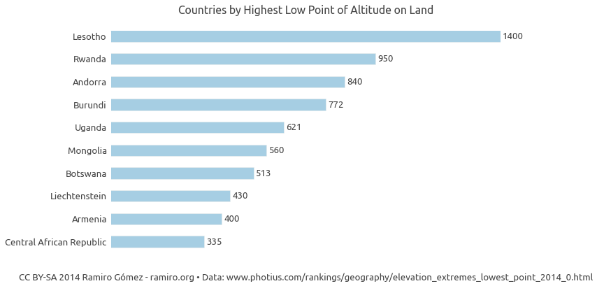
The country with the highest low point by far from those with data available is Lesotho with 1,400 m (4,593 ft) followed by Rwanda 950 m (3,117 ft) and Andorra 840 m (2,756 ft). See the top 10 ranking below:
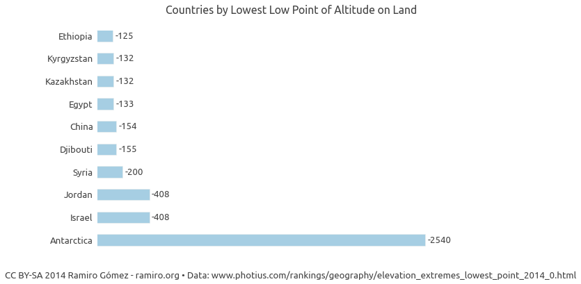
On the other side of the spectrum are Antarctica -2,540 m (-8,333 ft), which is not a country but a continent, followed by Jordan and Israel, which share the Dead Sea as the deepest point -408 m (-1,339 ft). The Dead Sea is considered a point on land, I assume because it is a lake completely surrounded by land.
The data for this map was downloaded from photius.com and is based on information from the CIA World Fact Book. The data was processed as shown in this IPython Notebook.
Using the Map
You can see the data value for an individual geographic unit (e .g. country, state, county) by moving the mouse over it.
You can zoom in by clicking on a unit and zoom out by clicking on the same unit or any point on the map outside of units.
Click on the button in the top menu to see the IPython notebook with the code to retrieve and process the data.
Click on the button in the top menu to see the data table used for the maps.
Click on the button to download the currently displayed map as a PNG image.
If you see in the top menu you can choose a color scheme from the drop down displayed on click.
If there is a menu item named Choose Dataset on the left in the top menu, you can choose different data series to display on the map from that drop down.
Credits
This map is created using the d3.geomap JavaScript library.
Published October 21, 2014 •
Data Source •
CC BY-SA 2014 Ramiro Gómez (@yaph)